Hiking routes Divcibare
There are six hiking routes on Divcibare. Aside from the longest (6 hours long) circular path which includes all mountain peaks, the other five routes are shorter, distance of approximately 1km, and it takes around 30-45 min to cross each one of them.
New! New! New! At Villa “Marina” you may use vouchers of Ministry of Tourism in the amount of 5.000 RSD for your holiday in Serbia. Find more on homepage.
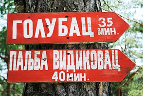
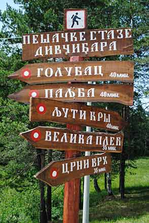
There are six footpaths on Divcibare: Centre – Golubac (1050 meters, 30 minutes), Center – Paljba (1051 meters, 40 minutes), Centre – Crni vrh (1093 meters, 35 minutes), Center – Velika plec (1036 meters, 45 minutes), Center – Ljuti krs (962 meters, 40 minutes) and circular path “Tops of Divcibare”(6 hours).
Center – Golubac
Height: 1050 meters; Length: 2 km; Duration: 30 minutes
You should climb down from Villa “Marina” to the Church of St.Panteleimon in the centre of Divcibare. Follow the paved road that climbs up toward hotel “Maljen”. After ten minutes of walk you will come to a crossroad where you should turn left and a gravel road will lead you next to the cottages. You will come to the spot recognized by the rare tall pines. From that point the road splits in two directions. Right direction leads you towards Golubac, and left toward Paljba.
Center - Paljba
Height: 1051 meters; Length: 2,5 km; Duration: 40 minutes.
You should climb down from Villa “Marina” to the Church of St.Panteleimon and continue beside the stream Zujan which you will cross after 500 meters. The path continues slightly upwards through the pine forest, then across the meadows, beside cottages, all the way to the main paved road. To avoid the paved road, you should turn left after 50 meters. After a small walk, go to the right side and follow the road through a small pine forest. This is the last stage, because very soon you will reach your goal, Paljba with 1051 meters of altitude. On one side you can see mountains of Valjevo, and on the other peaks of Maljen. There is a viewpoint with a spacious parking, just below the top, on the left side of the main road. The view stretches onto the villages in the valley: “Skakavci” and “Rosici”, “Razana” and “Kosjeric”. This spot is very attractive in the evening when the sun sets down.
Center - Crni vrh
Height: 1093 meters; Length: 1 km; Duration: 35 minutes.
Crni vrh is the name of the peak and the ski track. You should turn right from Villa “Marina”, follow the paved road uphill to the left (right downhill the path leads to the centre of Divcibare). After you climb up and pass the cottages, you will come to the crossroad with a wooden signpost: on the left, the road leads to Velika plec, but you should continue straight to the Crni vrh. Soon, you will enter the forest of pines, birches and firs. It is covered with grass, blueberries and dense ferns. The path is quite steep and intertwined with roots which form natural stairs together with stones and earth. The top is very near and here you can see a sign on the rock which specifies the height of 1093 meters. It is possible to see Ovcar, Kablar and Suvobor in the distance, and on a very sunny day Kopaonik, Golija, Tara, Zlatibor and Zvijezda are visible as well.
Center - Velika plec
Height: 1036 meters; Length: 2 km; Duration: 45 minutes.
Beginning your walk from Villa “Marina”, first part of the route is the same as for the Crni vrh. When your reach the spot with the wooden signpost, turn left and follow the gravel road that climbs through a conifer forest. Very soon, a new crossroad will appear. If you turn right you will once again go toward Crni vrh. But, straight ahead the road leads to Velika plec. After 800 meters of walk you will find yourself in the middle of the ski track Crni vrh. Then again, the path goes through a conifer forest for the next 400 meters. After that, the forest remains on the left side of the road, and on the right side you’ll see cottages and hills. There is a right curve at the end of this road and it passes through the picturesque part of the wood. This is the spot where you have reached an altitude of 1050 meters. There is a gorge of the river Kamenica at the foothill of Velike pleci and you can even hear the murmur of the river.
Center - Ljuti krs
Height: 962 meters; Length: 2 km; Duration: 40 minutes.
The viewpoint “Ljuti krs” is set on the 962 meters of altitude. Passing the camp “Breza”, you should turn left and this is the direction for Ljuti krs. You may see a signboard as well. The path passes through the wood, and between cottages. After the last cottage the trail turns to the right. A winding path crosses the stream and leads to the signboard for “Strazara” to the right and “Ljuti krs” to the left. When you turn left toward Ljuti krs you will enter the natural reserve “Crna reka”. Along the rocky ridge, the trail climbs to the top from where you can see the gorge of the river “Crna reka” and mountains Jablanik, Medvednik and Magles.